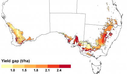
Yield Gap Australia is an interactive map based tool for grain growers, agronomists, research funders and policy makers. It shows the extent and geographic distribution of the yield gap (the gap between actual and potential crop yield) of rainfed wheat, barley, sorghum and canola crops in Australia.
To explore the yield gap maps:
- Access the map page (click on ‘Map’ in the menu, OR the ‘View Map’ button on this page);
- Choose what to display on the map from the drop-down lists left of the map.
- Click on any coloured area of the map to access yield and yield gap details at Statistical Areas Level 2 (SA2), GRDC Sub-region and region levels of resolution;
- Once you have the ‘Details’ table open, click on the ‘Compare my farm’ button to benchmark your farm against both the local average yields and the local water-limited yield potential allowing for your farm’s soil types.
Closing the yield gap is vital to all of us because future global food security depends on producing enough nutritious food for a world population expected to peak at over 9 billion people by 2050. At the same time we must also protect our carbon-rich and bio-diverse forests, wetlands, and grasslands. Future global food security clearly depends on achieving the highest possible yields on existing farm land.
Australian grain producers have responded to the pressures of rising production costs by participating in the rapid development and adoption of new and improved crop management practices over the last 20 to 30 years. How much more can they improve their productivity? To answer this question we need to know the current yield gap. Yet while average yield data have been well documented at local to regional scales, until recently there were few reliable data on yield potential or water-limited yield potential of crops in Australia.
Through the Yield Gap Australia website, GRDC and CSIRO are making maps of the best estimates of the Yield Gap available to the public, with the expectation that they will be used to:
- Benchmark individual farm yields against their water-limited potential and the local average yields on the same soil type
- Prioritize research and inform agricultural policies to ensure global food security through focus on regions with the largest unexploited yield gaps and greatest potential to close them through ecological intensification
- Help researchers to identify the causes of yield gaps and locations where new technologies or technology packages have greatest potential.
Our focus is on four of Australia’s biggest crops grown in rain-fed conditions: wheat, barley, sorghum and canola.